The Clear Creek Trail runs from the Platte River to Golden, Colorado, mostly following Clear Creek. The ride was 17.4 miles going and a bit less coming back, as I took some shortcuts, for a total or 33.75 miles. The starting elevation was 5169 feet and I topped out at 5727 feet just before entering Golden. My average speed was just over 10.5mph.
My starting point was at Twin Lakes. The Clear Creek trail head at the Platte River is about 2+ miles east of Twin Lakes, but much of that 2 miles is spent going under 3 freeways, 2 roads, multiple access roads, flyovers, etc. It is a very necessary section of trail but cold and dark this time of year.
In the next few miles the trail faithfully follows the creek and has only one crossing of a road. Elevation gain is almost continuous with only the occassional dip.
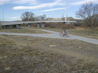 At mile 5.25 the Ralston Creek Trailhead is announced by an incredible cable stay bridge across Clear Creek.
Just across the bridge, at the confluence of Ralston Creek and Clear Creek is the place where gold was first discovered in Colorado. Here is what is generally reported about the strike:
"The first documented discovery of gold in the Rocky Mountain region occurred on 1850-06-22, when Lewis Ralston, a Georgia prospector headed for the California gold fields, dipped his sluice pan into this stream near its mouth at Clear Creek. [1] Ralston found about 1/4 ounce (6 g) of gold worth about five dollars. Ralston's companions named the stream Ralston's Creek in his honor, but they all left the next morning, drawn by the lure of the California gold fields.
In the Spring of 1858, William Green Russell and his brothers searched the creek for gold. Later in the year, Lewis Ralston brought another group of prospectors back to the site of his first discovery."
 But Ralston Creek is for another day and I head on up Clear Creek. At mile 5.8 the trail makes the first of its two ventures onto surface streets. The trail dead ends into Gray Street at 52nd Avenue. You proceed up Gray, staying to the right and in about 250 yards comes back to the creek and the trail.
As you ride west through Wheat Ridge much of the trail is blacktop rather than concrete. But it is well maintained, smooth, and without cracks.
Parks are dotted along the trail providing picnic and restroom facilities. Near Kipling Road the trail again ventures on local streets, follows a secondary trail under Kipling. Goes back onto a street and over a steep hill and back down to the trail. I have found ways around the hill. The creek doesn't go over the hill so why should I?
Since one has to go on the street anyway, I always take a side trip of a couple of blocks to visit a health food establishment. It is called Winchell's Donuts and I usually have a coffee and a couple of Custard filled energy buns.
The reconstruction of the trail under I-70 and the Highway 58 flyover is completed and much of the trail is new, wide, smooth concrete to the MacIntyre underpass. At this point the rider is facing some serious elevation change.


The trail makes an interim summit as it passes over the creek and then up the side of the mesa to a final crest. I took some pictures looking back down to try to give some perspective. This is about 12 or 13 miles into the ride. Most of what we are looking down on is the Coors Brewing Company.
You give back some of the elevation going down into Golden. The trail ends at Washington St. and is over a half a mile north of the creek. I rode south on the Washington St. Trail back to the creek where once again the trail headed west.


This portion is a bit of College Town artsy fartsy with signs, statues, art, cafes and appartments. There are also nice parks and the creek is well maintained.
And at mile 17.44 the trail ends and it is time to turn around and head for Denver.


